
Line 6 Info
- Network Paris Metro
- Operation Started 1910
- Total Length 13.7 km
- Total Stations 22
Terminals
From
Kléber
To
Picpus
Line 6 Overview
Line 6 runs between Charles de Gaulle-Étoile and Nation, forming a semicircular route in the southern part of Paris. The line is 13.6 kilometers long and has 28 stations. The line passes through several major areas such as Trocadero, Montparnasse, Place d'Italie, Bercy, and Nation. It also connects to several other metro lines, including lines 1, 2, 4, 8, 9, and 12. Line 6 is one of Paris's most scenic metro routes, as much of it runs above ground, providing clear views of landmarks such as the Eiffel Tower and the Seine River bridges.
Paris Metro Map 2026
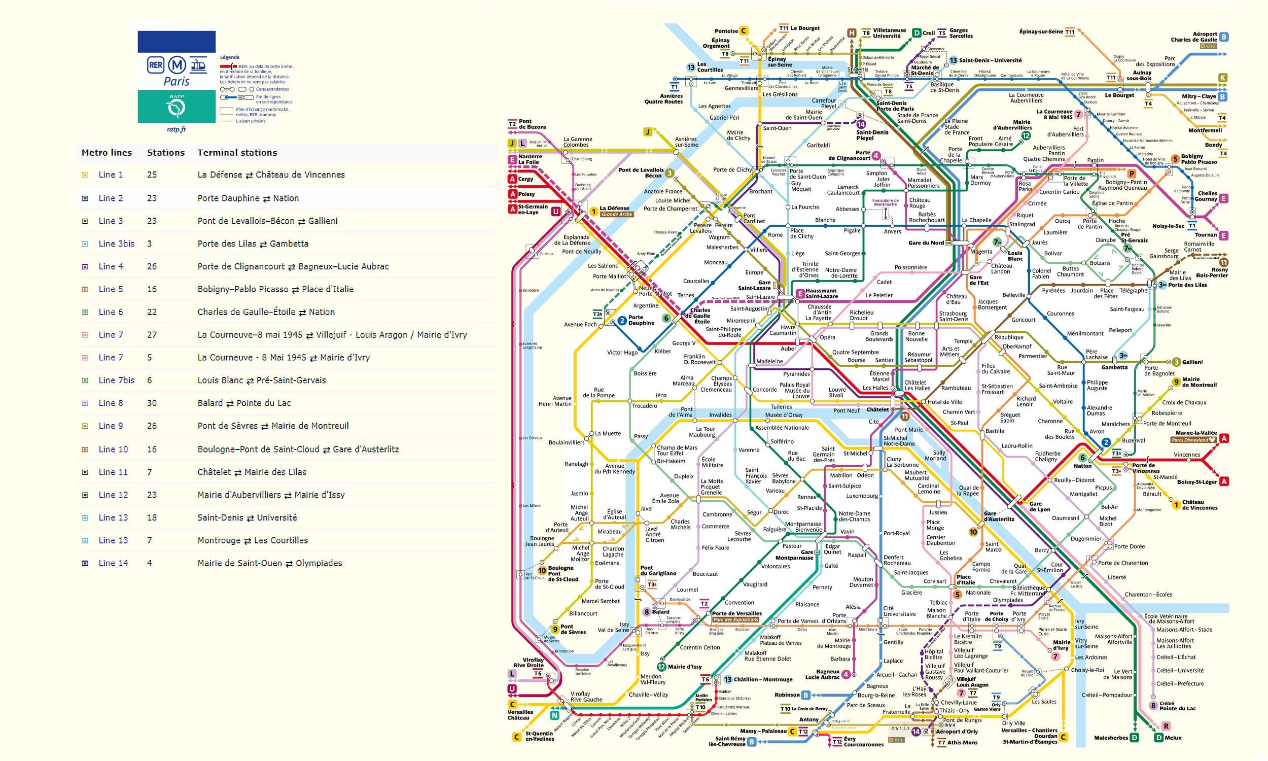
Click to expand
Other Lines in Paris Metro
Line 1
La Défense ↔ Château de Vincennes
25 stations
Line 10
Boulogne – Pont de Saint-Cloud ↔ Cardinal Lemoine
16 stations
Line 11
Chardon Lagache ↔ Rambuteau
7 stations
Line 12
Mairie d'Aubervilliers ↔ Mairie d'Issy
23 stations
Line 13
Les Courtilles ↔ Châtillon–Montrouge
7 stations
Line 13
Saint-Denis — Université ↔ Malakoff Rue Étienne Dolet
18 stations
Line 14
Saint-Denis Pleyel ↔ Olympiades
4 stations
Line 2
Porte Dauphine ↔ Avron
23 stations
Line 3
Pont de LevalloisBécon ↔ Gallieni
23 stations
Line 3bis
Porte des Lilas ↔ Pelleport
3 stations
Line 4
Porte de Clignancourt ↔ Bagneux-Lucie Aubrac
26 stations
Line 5
Bobigny Pablo Picasso ↔ Place d’Italie
16 stations
Frequently Asked Questions — Line 6
Line 6 has 22 stations on the Paris Metro network.
Line 6 runs between Kléber and Picpus.
Line 6 is approximately 13.7 km long.
Line 6 opened in 1910.
Line 6 is a Metro line operated under Paris Metro.
Line 6 is part of the Paris Metro transit network.