Route Finder

Jurong East to Nicoll Highway Metro Route

Fare for This Route

Passenger Fare
Adut S$2.20
Senior citizen
Concession fare
S$1.07

Based on 17.3–18.2 km for this journey.

15 stations2 interchanges18 km~36 min
Change to North–South Line towards Marina South Pier
Change to Circle Line towards HarbourFront
  1. 1
    Start at Jurong East Metro Station.
  2. 2
    Board the East–West Line towards Pasir Ris
    Ride 10 stops to Raffles Place.
    Change lines here
  3. 3
    Board the North–South Line towards Marina South Pier
    Ride 1 stop to Marina Bay.
    Change lines here
  4. 4
    Board the Circle Line towards HarbourFront
    Ride 3 stops to Nicoll Highway.
  5. Arrive at Nicoll Highway Metro Station. You have reached your destination.

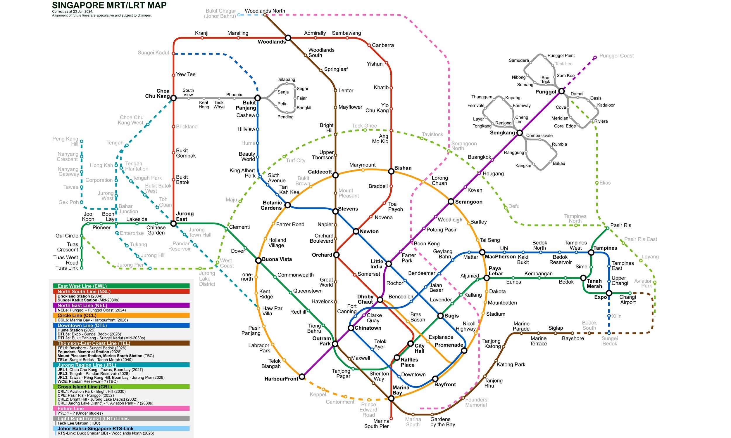
Singapore MRT Map 2026

Singapore MRT map
Click to expand

Jurong East to Nicoll Highway — Frequently Asked Questions

There are 15 stations on the route from Jurong East to Nicoll Highway, including the origin and destination.

You need to make 2 interchanges to travel from Jurong East to Nicoll Highway, using East–West Line and North–South Line and Circle Line.

The distance from Jurong East to Nicoll Highway is approximately 18 km by Metro.

The estimated journey time from Jurong East to Nicoll Highway is approximately 36 minutes.

You can travel from Jurong East to Nicoll Highway via East–West Line and North–South Line and Circle Line on the Singapore MRT.

To travel in the reverse direction from Nicoll Highway to Jurong East, follow the same route in the opposite direction. The journey takes approximately 36 minutes.

Fare for This Route

Passenger Fare
Adut S$2.20
Senior citizen
Concession fare
S$1.07

Based on 17.3–18.2 km for this journey.

Origin Gates

Jurong East

Gate A Jurong Gateway Road / Bus Interchange
Gate B IMM / International Business Park
Destination Gates

Nicoll Highway

Gate A Singapore Indoor Stadium / Sports Hub
Gate B Nicoll Highway / Golden Mile Complex
Gate C Kallang Road / Jalan Sultan