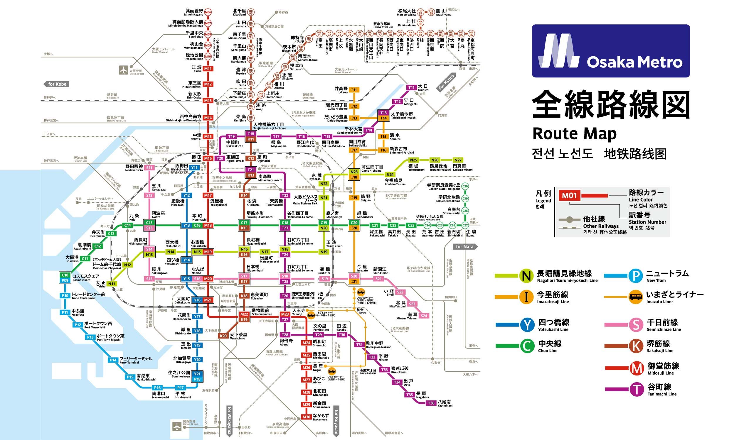
3 stations1 interchange2.3 km~5 min
Board
Midōsuji Line
Platform 1
towards Nakamozu
Change to
Tanimachi Line
Platform 1
towards Yaominami
- 1
-
2
Board the Midōsuji Line towards Nakamozu · from Platform 1
Ride 1 stop to Tennōji.Change lines here -
3
Board the Tanimachi Line towards Yaominami · from Platform 1
Ride 1 stop to Shitennōji-mae Yūhigaoka.
Origin
Dōbutsuen-mae (Shinsekai) Osaka
Gates / Exits
Gate No. 1
Osaka Tennoji Zoo / Tennoji Park (Art Museum) / Shinsekai and Tsutenkaku Tower / Ebisu-higashi 1- to 3-chome / Chausuyamacho
Gate No. 2
Osaka City University Hospital / Taishi 1- & 2-chome / Sanno 1- to 3-chome / City Bus
Gate No. 3
Kasumicho intersection NE corner
Gate No. 4
Kasumicho intersection SE corner / Osaka City University Hospital / Nishinari Police Station / Airin Kaikan (Rehabilitation consultation center) / Taishi 1- & 2-chome / Haginochaya 1- to 3-chome / Tengachaya-kita 1- & 2-chome / City Bus
Gate No. 5
Osaka Tennoji Zoo / Tennoji Park (Art Museum) / Shinsekai / Tsutenkaku Tower / Ebisu-higashi 1- to 3-chome / Chausuyamacho
Gate No. 6
Kasumicho intersection NW corner / JR Shin-Imamiya Sta. / Nankai Line / Hankai Line / Ebisu-nishi 2- & 3-chome / Airin Public Employment Security Office
Gate No. 8
Airin Kaikan (Rehabilitation consultation center) / Taishi 1- & 2-chome / Sanno 1- to 3-chome / Tengachaya-kita 1-chome
Gate No. 9
Nishinari Police Station / Haginochaya 1- to 3-chome / Tengachaya-kita 2-chome
Destination
Shitennōji-mae Yūhigaoka Osaka
Gates / Exits
Gate No. 1
Osaka Legal Affairs Bureau Tennoji Branch / Creo Osaka Central / Osaka IT Station / Welfare Center for the Blind / Tennoji Public Health Center (Annex) / Tennoji Fire Station / Tennoji Post Office / Tennoji Ward Office / Osaka International House Foundation / Osaka Prefectural Social Engagement Promotion Center for the Physically Impaired (Information Plaza Osaka) / Tennoji-ku Citizen’s Center / Rokumantaicho / Ikutama Maemachi / Ueshio 4- to 6-chome / Uehommachi 7- to 9-chome / Uenomiyacho / Komiyacho / City Bus
Gate No. 2
Tennoji-ku Citizen’s Center / Tennoji-ku Welfare Center for the Aged / Yuhigaokacho / Ikutama Teramachi / Shitaderamachi 1- & 2-chome / Shimodera 1- & 2-chome / Kozu 3-chome / Nippombashi-higashi 1- & 2-chome / Nippombashi 2-chome
Gate No. 3
Tennoji Home Care Service Center Yuai / Osaka Hospital Nenkin Kaikan / Tennoji Police Station / Rokumantaicho / Ueshio 6-chome / Uehommachi 9-chome / Shinpouincho / City Bus
Gate No. 4
Shitennoji Shrine / Shitennoji 1- & 2-chome / Katsuyama 1- & 2-chome
Gate No. 5
Osaka Yuhigaoka Prefectural Government Bldg. / Naniwaminami Osaka Prefectural Tax Office / Osaka Prefectural Automobile Tax Office / Kansai Patent Information Center / Aizendo / Kiyomizu-dera Temple / Oe-jinja Shrine / Yuhigaokacho / Reinincho / Shitaderamachi 1- & 2-chome / Osaka 1- & 2-chome / Shimodera 2- & 3-chome / Nippombashi-higashi 2- & 3-chome / Chausuyamacho